In the midnight of December 15, 2017, a 6.5-magnitude earthquake struck southern Indonesia at 11:47 p.m. (local time). The epicenter of the earthquake occurred on Java – a densely populated island in Indonesia, the United States Geological Survey said.
The quake was measured at a depth of 91 kilometres (56 miles) and struck less than a kilometer east-southeast to the coastal town of Cipatujah on the Java Island, USGS said.
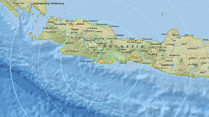
Although there was no immediate indication of a tsunami, a tsunami warning had been triggered for parts of the main island’s coastline. The tremor was felt across the island including in the nation’s capital of Jakarta, some 300 kilometres (190 miles) from the epicenter, local media reported.
The Indonesia’s National Disaster Mitigation Agency announced that the strong earthquake had caused severe damage to at least a hundred houses including schools and government offices across West and Central Java provinces. Damage was heaviest in the Tasikmalaya, Pangandaran and Ciamis regions of West Java Province near the epicenter. At least three people died following the strong earthquake. Temporary tents have been set up for those who have lost their homes. The agency is still evaluating the impact of the disaster and urge people to be cautious and stay alert.
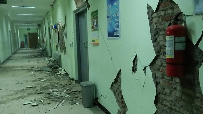
A hospital in Banyumas of the Central Java province suffered severe damage to ceilings, cracked walls and leaks to oxygen pipelines, forcing around 70 patients to be moved to temporary shelters, the agency said.
This earthquake is listed the 2nd largest earthquake in Indonesia in 2017, following a strong 6.7-magnitude earthquake off the coast of eastern Indonesia on October 24, 2017. No tsunami warning was issued and there were no immediate reports of casualties or damage following that earthquake.
Indonesia is located on the Pacific “Ring of Fire”, where tectonic plates collide. Earthquake is common in Indonesia as a result of frequent seismic and volcanic activities. According to EarthquakeTrake, Indonesia has had 485 earthquakes in the past 365 days (M1.5 or greater).
One year ago, a deadly earthquake struck Aceh, Indonesia on December 7, 2016, killing more than 100 people, injuring many others and leaving at least 43,000 people homeless.
On December 26, 2004, a 9.1-magnitude earthquake struck Aceh province, Indonesia. Some 230,000 lives were lost because of a large-scale tsunami triggered by the earthquake.
Leave a Reply